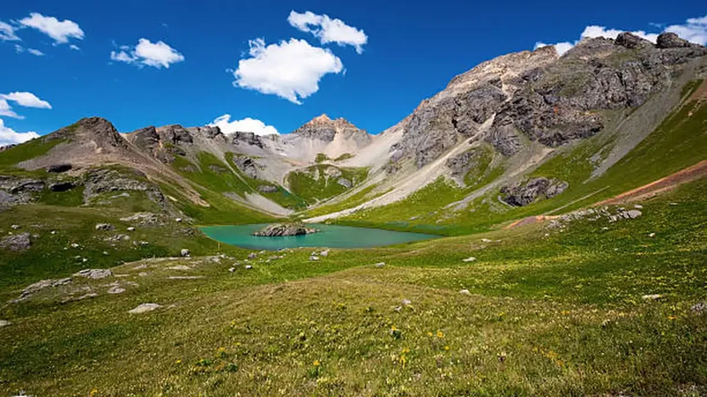
Most people who hike into the San Juan Mountains for Ice Lake never make the extra push to Island Lake — and that’s their loss. It’s a shorter side trip with an almost unfair reward: water so clear and so blue it looks photoshopped, ringed by 13,000-foot peaks that still hold snow in August.
Island Lake Colorado sits at roughly 12,400–12,700 feet in the Ice Lake Basin of the San Juan National Forest, about 4 miles from the South Mineral Campground trailhead near Silverton, Colorado. The hike gains around 2,500–3,000 feet over 6.5 to 8.4 miles round trip depending on your route, and it’s considered strenuous but doable for a fit day hiker.
What Is Island Lake and Where Is It?
Island Lake is one of four alpine lakes tucked into the upper Ice Lake Basin, alongside Ice Lake, Fuller Lake, and Clear Lake. All four sit above treeline in the San Juan Mountains, surrounded by rugged peaks like Pilot Knob, US Grant Peak, and Vermilion Peak.
You’ll find it off the Million Dollar Highway (US-550), between Ouray and Silverton, Colorado. The trailhead itself is reached by turning onto Forest Road 585, a few miles outside Silverton, and driving to South Mineral Campground.
What sets Island Lake apart from its more famous neighbor, Ice Lake, is color. Ice Lake runs a striking cobalt blue, while Island Lake often reads more turquoise-green — some hikers describe it as an emerald, almost Hawaiian shade. Neither photo does it justice until you’ve stood at the edge of it yourself.
Trail Stats at a Glance
Here’s where a lot of blog posts disagree, so let’s clear it up. The confusion comes from the fact that hikers measure the trip differently — some count only the direct route to Island Lake, others count the full loop through both lakes.
| Metric | Direct to Island Lake | Full Loop (Island Lake + Ice Lake) |
|---|---|---|
| Distance (round trip) | ~6.5 miles | 7.5–8.4 miles |
| Elevation gain | ~2,500 ft | ~2,500–3,000 ft |
| Trailhead elevation | ~9,800–10,000 ft | Same |
| Lake elevation | ~12,400–12,700 ft | Same |
| Difficulty | Strenuous | Strenuous |
| Typical time | 4–6 hours | 5–7 hours |
Both numbers are accurate — they’re just answering slightly different questions. If you only care about reaching Island Lake and turning around, use the shorter figures. If you’re doing the full basin loop through Ice Lake too, budget for the longer ones.
Quick Takeaway: Plan for a half-day minimum, more if you want time to sit at the lake and actually enjoy it instead of just checking a box.
Step-by-Step: Hiking to Island Lake
The First Two Miles
The trail starts right across from South Mineral Campground and doesn’t waste time getting steep. You’re in trees for a good stretch here, climbing a long series of switchbacks — some hikers count around 34 of them, though that number depends on how generously you define a switchback. This section is the least scenic part of the hike, so the advice from experienced hikers is simple: put your head down and grind through it.
Clear Creek Falls and the Junction
About a mile in, you’ll reach Clear Creek Falls, a good spot to catch your breath and refill water if you’re carrying a filter. From there, the trail keeps climbing until you hit a junction where the path splits toward Ice Lake and Island Lake.
This is the part almost nobody warns you about: the cutoff to Island Lake is not well marked, and the trail can be faint. Look for a waterfall visible in the distance and a trail branching off through open meadow. If you’re relying on a paper map or your memory of someone else’s blog post, download an offline GPS track before you go — cell service is nonexistent out here.
The Final Push to Island Lake
Once you’re on the Island Lake spur, the terrain opens into alpine meadow and wildflowers before delivering you to the lake itself, sitting at roughly 12,400 to 12,700 feet. The last stretch includes some loose rock and a short scramble in spots, so trekking poles help more than they might seem to at lower elevations.
Island Lake vs. Ice Lake — Which to See First
This is one of the most useful things to decide before you go, and most guides skip it entirely.
Hiking to Island Lake first, then over to Ice Lake, tends to work better logistically — once you crest the basin near Island Lake, the connector to Ice Lake is a short, mostly downhill stretch. Doing it in the reverse direction means climbing that connector, which some hikers find more tiring on already-tired legs.
That said, plenty of people do it the other way and have no complaints — the two lakes are close enough that either direction works. If you’re only doing one lake because of time or energy, Ice Lake is technically the more famous of the two, but multiple experienced hikers who’ve done both argue Island Lake is actually the more strikingly colored of the pair.
Getting There and Parking
From Silverton, drive north on US-550 (Million Dollar Highway) for a little over 2 miles, then turn west onto Forest Road 585. Follow this gravel road about 4 miles to South Mineral Campground — the trailhead parking lot is on the right, directly across from the campground entrance.
If you’re coming from Ouray, drive south on US-550 over Red Mountain Pass and watch for the FR 585 turnoff before you reach Silverton.
Parking fills fast. The lot routinely fills by 6:00–7:00 a.m. on summer weekends, and once it’s full, overflow parking along the road is limited and sometimes restricted. Realistically, plan to arrive before sunrise in July and August if you want a guaranteed spot. Getting there later means you may be sitting in your car waiting for a space to open up.
Camping Near Island Lake
South Mineral Campground sits right at the trailhead, which makes it the obvious base camp if you want an early start without the pre-dawn drive.
- 26 sites, mostly shaded, some creekside
- First-come, first-served — no reservations are taken
- Fee runs roughly $18–20 per night, though some recent visitor reports mention higher rates, so check current signage or the San Juan National Forest site before you go
- Open season is generally late May through late September; water and services are shut off outside that window
- Dispersed camping is allowed in designated spots along Forest Road 585 if the campground is full, though sites fill quickly and there’s no camping directly at the trailhead parking lot
If you’re backpacking rather than day hiking, camping at Ice Lake or Island Lake itself is common, though Leave No Trace practices matter more here than almost anywhere else in Colorado given how heavily used this basin is.
Best Time to Hike Island Lake
July through September is the reliable window. Snow can linger into July at this elevation, and wildflowers typically peak in mid-July, which is when the meadows around the basin look their best. By October, overnight temperatures drop fast and conditions can turn wintry with little warning.
Afternoon thunderstorms are common in summer, which is the real reason experienced hikers push for early starts — not just for parking, but to be off exposed terrain before storms roll in around midday.
What to Pack and Safety Tips
- Sturdy hiking boots — the trail has loose rock, scree, and stream crossings
- Water filter or purification tablets — natural water sources exist at Clear Creek Falls and near the lakes, but they’re untreated
- Layers — trailhead temps and lake-level temps can differ by 15–20 degrees, and wind at the lakes is common
- Sun protection — you’re above 10,000 feet for most of the hike, and UV exposure is intense
- Bug spray — mosquitoes can be aggressive in the meadow sections, especially early summer
- Trekking poles — genuinely useful on the steep descent, which is harder on knees than the climb up
On altitude: the trailhead itself sits close to 10,000 feet, and the lakes are above 12,000. If you’re coming from sea level or a lower-elevation state, give yourself a day or two in Silverton or Ouray beforehand. Headaches, nausea, or unusual shortness of breath are signs to slow down or turn back, not push through.
Dogs are generally welcome on leash, but the exposed scree sections near the lake can be tough on paws, so check conditions if you’re bringing one.
Nearby Peaks for Experienced Hikers
For those with scrambling experience, the Ice Lake Basin trailhead also serves as access to several technical peaks in the area, including Pilot Knob, US Grant Peak, and Vermilion Peak. These are not casual add-ons — they involve exposed class 3-4 terrain — but they’re worth knowing about if Island Lake leaves you wanting more of the basin.
Island Lake isn’t a secret anymore, and the crowded parking lot at 6 a.m. is proof of that. But even with the traffic, this is one of those hikes that earns its reputation the moment you crest that last rise and see the color of the water. Plan for an early start, pack a filter, and give yourself enough daylight to actually sit there for a while — that’s the part people always wish they’d done more of.
If you’re building out a bigger San Juan Mountains itinerary, Silverton and Ouray both make solid home bases, and a lot of hikers pair this trip with a soak in Ouray’s hot springs the next morning to give their legs a break.
If you’re planning another destination too, check out our Mountain West travel guides for more trip ideas.
FAQ Section
How long is the hike to Island Lake, Colorado?
Round trip distance ranges from about 6.5 miles if you go directly to Island Lake and back, up to 8.4 miles if you loop through both Island Lake and Ice Lake. Most hikers take 4–7 hours depending on the route and pace.
Is Island Lake harder than Ice Lake?
They share the same approach trail, so difficulty is nearly identical up to the junction. The final push to Island Lake includes a short, sometimes faint, unmarked cutoff with some loose rock, which trips up hikers who aren’t expecting it.
Do you need a permit to hike to Island Lake?
No permit is required for day hiking or backpacking in the Ice Lake Basin. You’ll just want to follow Leave No Trace practices given how heavily used the area is.
Where do you park for the Island Lake hike?
Park at the trailhead lot directly across from South Mineral Campground, reached via Forest Road 585 off US-550. Arrive before 6–7 a.m. in summer, since the lot fills quickly.
Can you swim in Island Lake, Colorado?
Yes, though the water is glacially cold year-round. Many hikers do take a quick dip, especially in Ice Lake, but be prepared for a shock to the system.
What is the elevation of Island Lake?
Island Lake sits at approximately 12,400 to 12,700 feet, depending on the exact point measured, with the trailhead starting around 9,800 to 10,000 feet.
Is Island Lake dog-friendly?
Dogs are generally allowed on leash, but the rocky, scree-covered sections near the lake can be hard on paws, so check trail conditions before bringing one.
What’s the best month to hike Island Lake?
July through September offers the most reliable conditions, with wildflowers typically peaking in mid-July. Snow can linger into early July at this elevation.