Most people who drive up to Sunrise head straight for the Skyline Trail’s cousin on the other side of the mountain — the famous Wonderland views everyone’s seen on Instagram. They’re missing the better hike. Burroughs Mountain puts you closer to Rainier’s ice than almost anywhere else you can walk to in a day.
The Burroughs Mountain Trail Mt Rainier is a 7.4–9.5 mile hike (depending on route) starting at Sunrise Visitor Center, climbing roughly 2,400 feet through alpine tundra to three rocky summits — First, Second, and Third Burroughs — with close-up views of the Emmons Glacier, Little Tahoma Peak, and Mount Rainier itself.
Why Hikers Love the Burroughs Mountain Trail
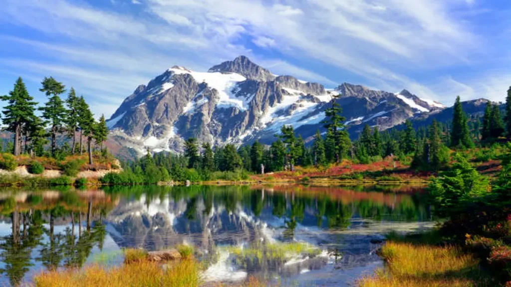
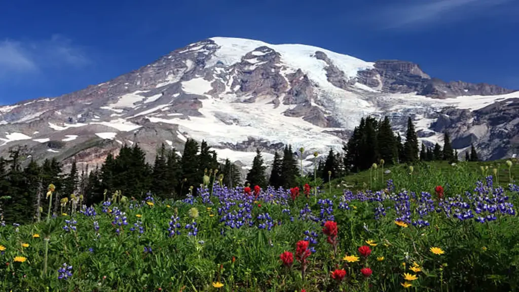
Sunrise is the highest point you can drive to in Mount Rainier National Park, and the Burroughs Mountain Trail uses that head start well. You climb through Sourdough Ridge with Rainier already filling the skyline, lose it briefly behind the first Burroughs, then walk out onto a flat, wind-scoured plateau where the mountain reappears at a scale that’s hard to process. Beyond it, the Cascades roll out toward Mount Baker and Glacier Peak.
This landscape isn’t typical Pacific Northwest hiking terrain. Above Frozen Lake, the trail crosses genuine alpine tundra — the most accessible stretch of it anywhere in the Cascade Range. It looks barren from a distance, then reveals dwarf lupine, mountain heather clumps that may be centuries old, and, depending on the week, marmots sunning on boulders or mountain goats picking along the ridgeline.
The other draw is proximity. From the Second and Third Burroughs, the Emmons and Winthrop Glaciers, the Russell Cliff, and Little Tahoma Peak sit close enough that you can watch actual mountaineers crossing “The Wedge” toward Camp Schurman on their way to summit day. No maintained trail in the park gets you nearer to the working glaciers of an active volcano.
Quick Takeaway: If you only have time for one hike from Sunrise, make it this one — it’s less crowded than the Skyline Trail at Paradise but arguably delivers a more dramatic, closer relationship with the mountain.
Burroughs Mountain Trail Routes: Loop vs. Out-and-Back
There are two practical ways to hike the Burroughs, and they share most of their mileage.
Out-and-back via Sourdough Ridge Trail. From the north side of the Sunrise parking area, you follow Sourdough Ridge to the Frozen Lake junction, continue up onto First and Second Burroughs, then return the way you came. It’s the shortest version and the most heavily trafficked, since Frozen Lake is also the junction point for the Mount Fremont Lookout and Dege Peak trails.
Loop via Sunrise Rim Trail. This version starts from the south side of the parking lot instead, passing Shadow Lake around the 1.2-mile mark before climbing to an overlook above the White River valley and Emmons Glacier. From there it continues onto First Burroughs, and you can either loop back east through Frozen Lake and Sourdough Ridge, or extend west onto Second and Third Burroughs before returning.
The loop adds only about half a mile compared to the out-and-back for the same elevation gain, and it trades a repetitive there-and-back walk for varied terrain, big wildflower meadows near the finish, and noticeably less foot traffic on the Sunrise Rim half. Given a choice, the loop is worth the extra half mile almost every time.
Trail Guide: First, Second, and Third Burroughs Mile by Mile
One of the best things about this hike is that it’s genuinely modular — you decide how far to go based on energy, weather, and snow conditions, and every turnaround point still earns its climb.
First Burroughs (bail-out option)
Roughly 0.3 miles past Sunrise Camp, you’ll pass the Glacier Overlook, a good first look at Rainier and the Emmons Glacier. First Burroughs itself isn’t a dramatic peak — you may cross it without quite noticing, recognizing it only when the trail flattens into open tundra and you hit the next junction. Distance to this point runs around 3 miles round trip with roughly 900 feet of gain, making it a reasonable option for hikers short on time or altitude tolerance.
Second Burroughs (most popular turnaround)
From the First Burroughs junction, stay left and continue about 0.6–0.7 miles further to Second Burroughs. This is where most day hikers stop, and for good reason — the northern face of Rainier, the Emmons Glacier, and Little Tahoma open up in full from here. Round trip to Second Burroughs runs close to 6 miles with about 1,000 feet of total elevation gain, a manageable day for most reasonably fit hikers.
Third Burroughs (for the full experience)
Past Second Burroughs, the trail descends into a saddle before climbing again to Third Burroughs — the closest point to Rainier on the entire route, and the spot with the best view straight up at the Winthrop Glacier and Russell Cliff. This adds real mileage and a final push that catches people off guard after an already long day, bringing the full loop to around 9 miles with roughly 2,400 feet of cumulative gain. It’s worth it if the weather’s clear, but it’s also the section most likely to still hold snow into midsummer, so check current conditions before committing.
Permits, Fees, and Sunrise Timed Entry
You do not need a separate wilderness or hiking permit to day-hike the Burroughs Mountain Trail. What you do need is a standard Mount Rainier National Park entrance — either a $30 per-vehicle weekly pass or an $80 annual America the Beautiful interagency pass, which covers every national park for a full year.
During the busiest stretch of summer, Sunrise has also required a separate Sunrise Timed Entry reservation for day-use vehicle access, bookable in advance through Recreation.gov starting in spring, with a smaller batch of next-day tickets typically released the evening before. Reservation windows and dates shift year to year based on park visitation trends, so check the current NPS Mount Rainier alerts page before your trip rather than assuming last summer’s system still applies.
If you’re planning to camp overnight — say, tacking on a stay at Glacier Basin near the Second Burroughs descent — that does require a separate backcountry wilderness permit, which is a different process from the day-use timed entry.
Dogs are not permitted on this trail, or on almost any trail inside Mount Rainier National Park, with the exception of certified service animals.
Best Time to Hike Burroughs Mountain Trail Mt Rainier
Sunrise Road itself typically opens in late June or around the Fourth of July and closes again in late September to mid-October, so your entire window to hike this trail is roughly three and a half months a year. Outside that stretch, the road is gated and inaccessible under snow — Mount Rainier is among the snowiest places on the planet, and this stretch sits high enough to hold onto winter longer than almost anywhere else in the park.
Even once the road opens, snow lingers on the tundra plateau well into July, particularly on the north-facing sections near Frozen Lake and on the approach to Third Burroughs. Late July through August is the sweet spot for a mostly snow-free trail, warm weather, and peak wildflower bloom, though it’s also the most crowded window. Early September brings thinner crowds and the first hints of fall color across the tundra, with a real chance of an early snow event depending on the year.
Getting There and Parking
The trailhead sits at the Sunrise Visitor Center, accessed via the White River entrance in the park’s northeast corner — about two hours southeast of Seattle or three and a half hours northeast of Portland. From the White River entrance, follow Highway 410 to Sunrise Park Road and continue to its western terminus, keeping right at the junction with the White River Campground access road.
Parking is a large lot at Sunrise, but it fills fast. Reviewers consistently note the lot as manageable before 8 a.m. and packed by midday during peak summer weekends, so arrive early both for parking and to beat the crowd through the narrow first mile of trail near Frozen Lake.
What to Pack for an Exposed Alpine Hike
This is a ridge-line hike with essentially no tree cover for the majority of its length, which changes your packing list compared to a typical forested PNW trail.
- Sun protection — hat, sunglasses, and sunscreen matter more here than shade-dependent hikers expect
- Layers for wind — the exposed tundra plateau is routinely windier and colder than the parking lot
- More water than you’d bring for equivalent mileage elsewhere, since there’s little shade to rest in
- Traction device (microspikes) if hiking in June or early July, when snowfields still cross the trail
- A paper map or the Green Trails Mt. Rainier East No. 270 map, since junctions near Frozen Lake can be confusing in fog
- Sturdy boots — the tread is loose, sandy volcanic material in sections and can be slick when wet
Wildlife, Wildflowers, and Tundra Etiquette
The alpine tundra above Frozen Lake is fragile enough that off-trail footsteps can take years to recover, so every credible source on this hike repeats the same request: stay on the marked trail, even when the ground looks like bare rock or dirt.
Mountain goats and marmots are common sights along the ridge, and black bears do live in the broader park, though sightings on the Burroughs itself are rare — most hikers report seeing more goats and marmots than anything else, and bear spray isn’t considered necessary on this particular trail the way it might be at Spray Park. Wildflower displays peak in late July and early August, with dwarf lupine and mountain heather among the standouts in a landscape that otherwise looks too harsh to support much plant life.
Burroughs Mountain vs. Skyline Trail: Which Should You Hike?
| Burroughs Mountain Trail | Skyline Trail (Paradise) | |
|---|---|---|
| Location in park | Sunrise (northeast) | Paradise (south) |
| Distance | 7.4–9.5 miles | ~5.5 miles |
| Crowds | Moderate | Heavy |
| Terrain | Alpine tundra, exposed | Meadows, some forest |
| Closest view of Rainier | Yes — arguably the closest maintained-trail view in the park | Close, but from a different angle |
| Permit needed | Park entrance + timed entry (seasonal) | Park entrance + timed entry (seasonal) |
If your priority is fewer people and the closest possible look at Rainier’s glaciers, Burroughs wins. If you want classic wildflower-meadow postcard shots with the most established infrastructure, Skyline still has the edge. Many experienced Rainier hikers do both on the same trip, one per side of the mountain.
Final Thoughts on the Burroughs Mountain Trail, Mt Rainier
The Burroughs Mountain Trail at Mt Rainier rewards exactly the amount of effort you’re willing to put in — a short walk to First Burroughs still earns a real view, and pushing all the way to Third Burroughs puts you as close to Rainier’s ice as a day hike gets. Check the Sunrise Timed Entry status before you go, pack for wind and sun rather than shade, and give yourself the full loop if your legs and the weather cooperate.
If you’re planning another destination too, check out our Washington State hiking guides for more trip ideas.
Frequently Asked Questions
How long is the Burroughs Mountain Trail?
It ranges from about 3 miles round trip to First Burroughs, to roughly 6 miles for Second Burroughs, up to a full 9–9.5 mile loop covering all three Burroughs via the Sunrise Rim Trail.
Is the Burroughs Mountain Trail hard?
It’s rated moderate to hard depending on how far you go. The elevation gain (up to 2,400 feet) is manageable, but sections of unmaintained, sandy trail and possible snow patches add real difficulty even on shorter turnaround options.
Do I need a permit for the Burroughs Mountain Trail?
No separate hiking permit is required for a day hike, but you need a park entrance pass and, during peak summer, a Sunrise Timed Entry reservation booked through Recreation.gov.
When does the Sunrise Road open for this hike?
Typically late June or around July 4th, closing again in late September to mid-October, depending on snowpack that year.
Can you see Mount Rainier up close from Burroughs?
Yes — from Second and Third Burroughs you get some of the closest maintained-trail views of the Emmons Glacier, Winthrop Glacier, and Little Tahoma Peak anywhere in the park.
Is the loop route worth the extra distance?
Most experienced hikers say yes. It’s roughly half a mile longer than the out-and-back but trades repetitive terrain for wildflower meadows and lighter crowds on the Sunrise Rim half.
Are dogs allowed on the Burroughs Mountain Trail?
No, dogs aren’t permitted on this or almost any trail in Mount Rainier National Park, apart from certified service animals.
What’s the best month to hike it with the least snow?
Late July through August offers the most reliably snow-free trail and peak wildflower bloom, though it’s also the busiest window.