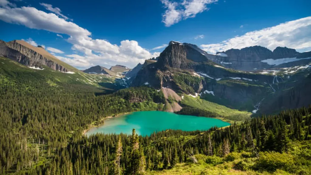
Most people roll into West Glacier with one afternoon and a vague plan to “see the glaciers.” That’s how you end up standing in a packed parking lot at 11 a.m., trailhead full, wondering if you should’ve left the hotel two hours earlier.
West Glacier hikes range from a flat half-mile boardwalk through old-growth cedars to a 13-mile trek to a historic backcountry chalet. The area anchors the west side of Glacier National Park, near Apgar Village and Lake McDonald, and it’s the easiest entry point into trails leading to Sperry Glacier, the Highline Trail, and Grinnell Glacier.
Easy West Glacier Hikes
If you’re short on time, traveling with kids, or just want a trail that won’t wreck your knees, start here.
Trail of the Cedars
This is the trail people mean when they say “something easy to stretch our legs.” It’s a boardwalk loop through old-growth cedar and hemlock, and it’s fully accessible — strollers and wheelchairs manage it fine. It’s short enough to knock out before dinner and still leaves the rest of your day open.
Quick Takeaway: Best pick if you have under an hour and want a taste of the forest without committing to a real hike.
Avalanche Lake
The most popular short hike on the west side of the park, and for good reason. It’s roughly six miles round trip, gaining a modest amount of elevation through dense, Pacific-Northwest-style forest before opening onto a lake backed by granite cliffs and hanging waterfalls. Go for sunset if you can — the rock face picks up an orange glow that photos never quite capture.
One thing worth knowing before you go: bear activity is common on this trail. Keep bear spray accessible, not buried in your pack, and make noise on blind corners.
Johns Lake Loop
A quieter, shorter alternative near Lake McDonald that most visitors skip entirely because it’s not as photogenic as Avalanche Lake. That’s exactly why it’s worth the mile-and-change loop if you want forest and a small lake without the crowds.
Moderate Hikes Worth the Extra Effort
These take a half-day and reward you with views you don’t get from the easy trails.
Apgar Lookout
Steep, exposed, and short on shade — but the payoff is a working fire lookout with views over Lake McDonald and the peaks rising behind it. Figure roughly 1,900 feet of gain over about four miles to the summit. Start early; there’s no tree cover once you’re above the switchbacks, and it gets brutally hot on summer afternoons.
Numa Ridge to Bowman Lake
A drive up the North Fork Valley gets you to Bowman Lake, then a sustained climb up Numa Ridge to another active fire tower. Fewer people do this one simply because it requires more driving from West Glacier, which makes it a solid pick if crowds are your main concern.
Quick Takeaway: If Apgar Lookout’s parking lot looks full, Numa Ridge is the quieter backup with a similar payoff.
Strenuous, All-Day Hikes
Block out most of a day for these. Bring layers, food, and a real water plan.
Sperry Chalet and Sperry Glacier
At around 13 miles round trip with roughly 3,500 feet of elevation gain, this is a full-day commitment starting at Lake McDonald’s shoreline. You’ll climb through forest into Glacier Basin, pass the historic Sperry Chalet, and — if you push on — reach the ice of Sperry Glacier itself near Comeau Pass, where the ascent tops out near 4,986 feet of total gain via the Gunsight Pass connector. Temperatures swing hard between the lake and the pass; pack a dry layer for the descent.
Piegan Pass and Siyeh Pass
Both climb toward the Continental Divide and top out with sweeping views of the Livingston and Lewis Ranges — Piegan Pass sits at roughly 7,570 feet. These are technically accessed from Going-to-the-Sun Road rather than directly from West Glacier, so budget drive time on top of trail time if you’re basing out of Apgar.
Iconic Glacier Views (Worth the Drive)
Not walkable from West Glacier itself, but these are the hikes most people are actually picturing when they search for glacier views in the park — so they earn a spot here.
Highline Trail and the Garden Wall
A steep alpine ridge, often snow-covered well into summer, with optional scrambles to overlooks along the way. The main trail doesn’t require scrambling, but the side trips to the Grinnell Glacier Overlook do, and that’s where most of the best photos come from.
Grinnell Glacier
A moderately challenging out-and-back through alpine meadows and past waterfalls, ending at views of the glacier and its iceberg-dotted lake. It’s one of the most-requested hikes in the park for a reason — just don’t expect solitude.
2026 Access Rules You Need to Know Before You Go
This is the part that trips up people using last year’s trip report as their guide. For the 2026 season, the National Park Service suspended the timed-entry vehicle reservation system across the park — Going-to-the-Sun Road, North Fork, Many Glacier, and Two Medicine all included. You can drive in whenever your entrance is open; no advance booking required.
That doesn’t mean parking is unlimited. Starting July 1, 2026, private-vehicle parking at Logan Pass is capped at three hours, aimed at increasing turnover during peak season. If you’re hiking Highline or Hidden Lake Overlook from Logan Pass, plan your timing around that window or use the shuttle instead.
Speaking of shuttles: for 2026, Trail of the Cedars and Avalanche Lake are not served by park shuttles, so you’ll need your own vehicle or a rideshare to those trailheads. A ticketed shuttle to Logan Pass is being piloted for longer alpine hikes — check availability before you rely on it.
International visitors should also budget for a policy change that took effect January 1, 2026: a $100 non-resident surcharge on top of the standard entrance fee for visitors 16 and older, and a $250 non-resident annual pass versus $80 for U.S. residents.
| What changed for 2026 | Old rule | New rule |
|---|---|---|
| Vehicle reservation | Required (2021–2025 pilot) | Suspended parkwide |
| Logan Pass parking | Unlimited duration | 3-hour limit (from July 1) |
| Shuttle stops | Included Avalanche Lake/Trail of Cedars | Those two stops dropped |
| Non-resident fees | Standard fee only | +$100 surcharge; $250 annual pass |
Safety, Timing, and Trail Etiquette
Bear activity is a real, everyday consideration here — not a footnote. Carry bear spray where you can reach it in under three seconds, hike in groups when possible, and make noise on trails with limited visibility, especially near Avalanche Lake and anywhere along McDonald Creek.
Water crossings on trails like Sperry can run high with snowmelt into early July, so check current trail status before committing to the longer routes. And on the exposed climbs — Apgar Lookout especially — start at first light in July and August; there’s no shade once you clear the treeline, and afternoon heat on switchbacks is no joke.
Best time of year: Late June through September covers most trails, though high passes like Piegan and Siyeh can hold snow into July. Shoulder season (early June, late September) trims the crowds but narrows which trails are actually open.
Bottom Line
Pick your hike based on time and legs, not just the photo that made you want to come here. Trail of the Cedars and Avalanche Lake cover the easy end; Apgar Lookout and Numa Ridge fill the moderate middle; Sperry Glacier, Piegan Pass, and Siyeh Pass are your full-day options. Whatever you choose, build your day around the 2026 access rules above — a three-hour parking limit at Logan Pass will wreck an unplanned itinerary faster than a wrong turn will.
If you’re mapping out a multi-day trip, start with one easy hike to acclimate, then build up to the strenuous routes once you’ve got your legs under you.
You might also find our Mountain West travel guides helpful when planning the rest of your trip.
FAQ Section
What is the easiest hike near West Glacier?
Trail of the Cedars is the easiest — a short, flat, boardwalk loop through old-growth forest near Lake McDonald. It’s accessible for strollers and wheelchairs and takes under an hour.
Do I need a vehicle reservation for Glacier National Park in 2026?
No. The National Park Service suspended the timed-entry vehicle reservation system parkwide for the 2026 season, including Going-to-the-Sun Road, North Fork, Many Glacier, and Two Medicine.
How long is the Avalanche Lake hike?
About six miles round trip with modest elevation gain. It’s one of the most popular hikes on the west side of the park and can get crowded by mid-morning in summer.
Is the Sperry Glacier hike difficult?
Yes — it’s roughly 13 miles round trip with about 3,500 feet of elevation gain, making it a full-day, strenuous hike best suited to experienced hikers with an early start.
Can I access the Highline Trail from West Glacier?
Not directly. The Highline Trail starts at Logan Pass along Going-to-the-Sun Road, which requires a drive from West Glacier and, starting July 1, 2026, a 3-hour parking limit at Logan Pass.
Do parks shuttles still stop at Avalanche Lake and Trail of the Cedars?
No. For 2026, both stops were dropped from the shuttle system, so you’ll need your own transportation to those trailheads.
What should I know about bears on these trails?
Bear activity is common, especially around Avalanche Lake and McDonald Creek. Carry accessible bear spray, hike in groups when possible, and make noise on blind corners.
Are there extra fees for international visitors in 2026?
Yes. A $100 non-resident surcharge applies to visitors 16 and older on top of the standard entrance fee, and the non-resident annual pass costs $250 versus $80 for U.S. residents.