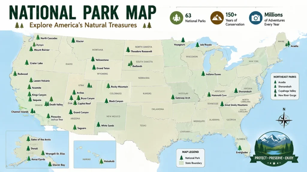
America’s national parks stretch far beyond the famous landscapes of Yellowstone, Yosemite, and the Grand Canyon. They include tropical islands, Arctic wilderness, deserts, volcanoes, mountains, wetlands, caves, coastlines, and forests scattered across the country and U.S. territories.
A national park map shows where the 63 congressionally designated U.S. national parks are located and helps travelers understand their geographic relationships. The parks extend from Maine and Florida to Alaska, Hawaii, American Samoa, and the U.S. Virgin Islands, making a map one of the simplest ways to start planning a national park trip.
How to Use a national park map
A national park map can answer a surprisingly large number of trip-planning questions before you start researching individual destinations.
At the simplest level, it tells you where a park is. A more detailed map can also reveal entrances, highways, visitor centers, campgrounds, hiking trails, lakes, rivers, elevation, nearby towns, and connections between neighboring parks.
The key is choosing the right map for the job.
| Map type | Best use |
|---|---|
| U.S. national parks map | Seeing all 63 parks at once |
| Interactive map | Exploring locations and nearby destinations |
| State map | Finding parks within one state |
| Official NPS park map | Planning roads, facilities, and major attractions |
| Trail map | Hiking and route planning |
| Topographic map | Backcountry navigation and terrain |
| Offline map | Traveling where cellular service is unreliable |
| Printable PDF map | Carrying a physical reference |
| Regional map | Planning multi-park road trips |
The National Park Service map catalog is particularly useful when you need authoritative maps. The NPS provides more than 1,000 maps that can be searched by park, state, or keyword, with many available as JPEG or PDF files.
National park vs. National Park System
One distinction prevents a lot of confusion.
The United States has 63 places carrying the formal “National Park” designation, but the National Park Service manages a much larger collection of protected and historic places.
The broader National Park System includes national monuments, national historic sites, battlefields, recreation areas, parkways, seashores, lakeshores, rivers, trails, and other designations.
That is why one map may show 63 national parks while another NPS map appears to contain hundreds of locations. They are mapping different categories.
U.S. national park map by Region
Looking at all 63 parks as isolated dots isn’t always the best way to understand their geography. Grouping them geographically makes the pattern much clearer.
The West contains the greatest concentration of famous mountain, canyon, desert, and volcanic parks. Alaska contains enormous wilderness parks separated by vast distances. Eastern parks tend to be closer to major population centers, while Hawaii, American Samoa, and the U.S. Virgin Islands require completely different travel strategies.
Western United States
The American West is the heart of many classic national park road trips.
California alone contains nine national parks:
- Channel Islands
- Death Valley
- Joshua Tree
- Kings Canyon
- Lassen Volcanic
- Pinnacles
- Redwood
- Sequoia
- Yosemite
California’s parks range from Pacific islands and giant redwood forests to the Sierra Nevada and the desert environment of Death Valley.
Utah is another obvious cluster on a national parks map. Its five parks—Arches, Bryce Canyon, Canyonlands, Capitol Reef, and Zion—are commonly called Utah’s Mighty 5.
Arizona contains Grand Canyon, Petrified Forest, and Saguaro. Nevada shares Death Valley with California and Great Basin sits entirely within Nevada.
Washington has Mount Rainier, North Cascades, and Olympic, while Oregon is home to Crater Lake.
Rocky Mountains and Interior West
Moving inland reveals another major group.
Colorado has four national parks:
- Black Canyon of the Gunnison
- Great Sand Dunes
- Mesa Verde
- Rocky Mountain
Wyoming is associated with Yellowstone and Grand Teton, although Yellowstone also extends into Montana and Idaho.
Montana contains Glacier National Park and part of Yellowstone.
These parks look reasonably close on a nationwide map, but distances can be deceptive. Mountain roads, seasonal closures, and limited entrance points may turn what appears to be a short connection into several hours of driving.
Alaska
Alaska stands apart on virtually every national park map.
It has eight national parks:
- Denali
- Gates of the Arctic
- Glacier Bay
- Katmai
- Kenai Fjords
- Kobuk Valley
- Lake Clark
- Wrangell–St. Elias
A conventional road-trip map is less useful here because several parks cannot simply be reached by driving to an entrance gate.
Gates of the Arctic, for example, has no roads or established trails running into the park. Remote Alaska travel can involve bush planes, boats, air taxis, or substantial backcountry planning.
This is one reason an Alaska inset on a national map should be treated as an overview rather than a navigation tool.
Hawaii and the Pacific
Hawaii has two national parks: Haleakalā National Park on Maui and Hawaiʻi Volcanoes National Park on Hawaiʻi Island.
Farther southwest, the National Park of American Samoa protects tropical ecosystems across several islands in the South Pacific.
The official NPS Park Map Finder demonstrates just how geographically broad the system is, spanning the contiguous United States, Alaska, Hawaii, Guam, American Samoa, Puerto Rico, and the U.S. Virgin Islands.
Eastern United States
National parks become more geographically dispersed east of the Mississippi.
Maine has Acadia, while Virginia has Shenandoah. Kentucky contains Mammoth Cave, Indiana has Indiana Dunes, and Ohio has Cuyahoga Valley.
Great Smoky Mountains National Park straddles Tennessee and North Carolina.
West Virginia’s New River Gorge National Park and Preserve is one of the newer additions to the 63-park list.
Florida offers a distinctive cluster with Biscayne, Dry Tortugas, and Everglades.
Midwest, Great Plains, and Texas
South Dakota contains Badlands and Wind Cave. North Dakota has Theodore Roosevelt National Park.
Minnesota is home to Voyageurs, while Michigan contains Isle Royale, an island wilderness in Lake Superior.
Missouri’s Gateway Arch is geographically and visually very different from the huge wilderness landscapes many people associate with national parks.
Texas has two major parks in its western reaches: Big Bend and Guadalupe Mountains.
Arkansas has Hot Springs National Park, while New Mexico contains Carlsbad Caverns and White Sands.
U.S. Virgin Islands
Virgin Islands National Park lies on St. John in the Caribbean.
Its location is a useful reminder that a complete U.S. national parks map needs more than a mainland outline. Alaska, Hawaii, American Samoa, and the U.S. Virgin Islands normally appear in separate inset maps because plotting everything at the same scale would make a nationwide map difficult to read.
Complete List of the 63 U.S. National Parks
If you’re using a national park map as a checklist, this alphabetical list gives you a quick reference.
| # | National Park | State or Territory |
|---|---|---|
| 1 | Acadia | Maine |
| 2 | National Park of American Samoa | American Samoa |
| 3 | Arches | Utah |
| 4 | Badlands | South Dakota |
| 5 | Big Bend | Texas |
| 6 | Biscayne | Florida |
| 7 | Black Canyon of the Gunnison | Colorado |
| 8 | Bryce Canyon | Utah |
| 9 | Canyonlands | Utah |
| 10 | Capitol Reef | Utah |
| 11 | Carlsbad Caverns | New Mexico |
| 12 | Channel Islands | California |
| 13 | Congaree | South Carolina |
| 14 | Crater Lake | Oregon |
| 15 | Cuyahoga Valley | Ohio |
| 16 | Death Valley | California, Nevada |
| 17 | Denali | Alaska |
| 18 | Dry Tortugas | Florida |
| 19 | Everglades | Florida |
| 20 | Gates of the Arctic | Alaska |
| 21 | Gateway Arch | Missouri |
| 22 | Glacier | Montana |
| 23 | Glacier Bay | Alaska |
| 24 | Grand Canyon | Arizona |
| 25 | Grand Teton | Wyoming |
| 26 | Great Basin | Nevada |
| 27 | Great Sand Dunes | Colorado |
| 28 | Great Smoky Mountains | Tennessee, North Carolina |
| 29 | Guadalupe Mountains | Texas |
| 30 | Haleakalā | Hawaii |
| 31 | Hawaiʻi Volcanoes | Hawaii |
| 32 | Hot Springs | Arkansas |
| 33 | Indiana Dunes | Indiana |
| 34 | Isle Royale | Michigan |
| 35 | Joshua Tree | California |
| 36 | Katmai | Alaska |
| 37 | Kenai Fjords | Alaska |
| 38 | Kings Canyon | California |
| 39 | Kobuk Valley | Alaska |
| 40 | Lake Clark | Alaska |
| 41 | Lassen Volcanic | California |
| 42 | Mammoth Cave | Kentucky |
| 43 | Mesa Verde | Colorado |
| 44 | Mount Rainier | Washington |
| 45 | New River Gorge | West Virginia |
| 46 | North Cascades | Washington |
| 47 | Olympic | Washington |
| 48 | Petrified Forest | Arizona |
| 49 | Pinnacles | California |
| 50 | Redwood | California |
| 51 | Rocky Mountain | Colorado |
| 52 | Saguaro | Arizona |
| 53 | Sequoia | California |
| 54 | Shenandoah | Virginia |
| 55 | Theodore Roosevelt | North Dakota |
| 56 | Virgin Islands | U.S. Virgin Islands |
| 57 | Voyageurs | Minnesota |
| 58 | White Sands | New Mexico |
| 59 | Wind Cave | South Dakota |
| 60 | Wrangell–St. Elias | Alaska |
| 61 | Yellowstone | Wyoming, Montana, Idaho |
| 62 | Yosemite | California |
| 63 | Zion | Utah |
Current national park mapping resources consistently identify 63 congressionally designated national parks.
Which States Have the Most National Parks?
The nationwide distribution is far from even.
California leads with nine national parks, while Alaska has eight. Utah’s five parks form one of the most convenient concentrations for travelers interested in combining multiple parks.
Colorado has four. Arizona, Florida, and Washington each have three.
This concentration matters when you’re planning around limited vacation time.
A visitor could potentially build one trip around Zion, Bryce Canyon, Capitol Reef, Canyonlands, and Arches. Trying to “combine” an Alaskan park with a Hawaiian park simply because both appear as insets on the same map obviously requires a very different itinerary.
Parks that cross state boundaries
Not every park fits neatly inside one state.
Yellowstone extends across Wyoming, Montana, and Idaho. Death Valley reaches California and Nevada, while Great Smoky Mountains covers portions of Tennessee and North Carolina.
That matters when filtering parks by state. Different lists may count a shared park under every state it touches, so adding state totals together does not necessarily equal 63.
Best National Park Map for Trip Planning
The most useful approach is not to rely on a single map.
Use several layers of information, moving from broad geography to precise navigation.
1. Start with a map of all 63 parks
First decide which part of the country interests you.
A nationwide map quickly reveals natural clusters such as:
- Utah’s Mighty 5
- Yellowstone and Grand Teton
- Sequoia and Kings Canyon
- Washington’s three national parks
- Arizona and southern Utah parks
- South Dakota’s Badlands and Wind Cave
- Florida’s three national parks
At this stage, you are looking for geographic relationships rather than trail-level detail.
2. Switch to an interactive national parks map
An interactive map becomes useful once you have narrowed the region.
You can zoom into crowded areas, inspect roads, identify nearby towns, and understand how the parks relate to other public lands.
The NPS Park Map Finder allows users to zoom into individual NPS locations and access links to park home pages, map pages, and printable brochure maps.
3. Open the official individual park map
Once you’ve selected a destination, stop relying on the nationwide map.
Official park maps are designed around the features visitors actually need.
Depending on the park, they can show:
- Entrance stations
- Visitor centers
- Park roads
- Campgrounds
- Picnic areas
- Trailheads
- Ranger stations
- Restrooms
- Scenic viewpoints
- Rivers and lakes
- Shuttle stops
- Accessibility information
- Nearby highways
For example, the official Arches map information includes distances and approximate driving times from the entrance and visitor center to destinations such as Balanced Rock, The Windows, Delicate Arch Trailhead, and Devils Garden.
4. Download maps before leaving home
This small step matters more than many first-time visitors expect.
Cellular coverage can become weak or disappear completely inside remote parks. A map that exists only in a browser isn’t much help when your phone loses its connection.
The free NPS app offers park information and maps, and official NPS park pages recommend downloading content for offline use where available. Olympic National Park, for example, specifically points visitors toward NPS app maps that can work online and offline.
5. Carry a paper or appropriate topographic map when necessary
Digital mapping is convenient, but it shouldn’t automatically replace physical navigation tools.
This is especially true for wilderness hiking.
Yellowstone’s NPS guidance specifically recommends carrying a topographic map for hiking because topo maps provide greater detail and do not depend on battery power.
A screenshot of a general park map is not a substitute for a proper backcountry map.
Quick Takeaway: Use a nationwide map to choose your destination, an interactive map to understand the region, an official park map for facilities and roads, and a trail or topographic map when heading into the backcountry.
Printable national park map vs. Interactive Map
Both formats are useful, but they solve different problems.
Printable maps
A printable national park map is ideal when you want:
- A trip-planning overview
- A physical checklist
- A road-trip reference
- Something that works without electricity
- A wall map or educational resource
PDF is generally the better format when printing because it maintains cleaner lines and text at larger sizes.
The NPS cartography collection provides maps in several formats, including PDFs and JPEGs. Official Harpers Ferry Center cartography resources have long provided downloadable maps for NPS sites.
Interactive maps
Interactive maps are better for exploration.
You can pan and zoom instead of trying to fit the entire country onto one page. They are especially useful where several parks are located close together.
Interactive maps may also make it easier to examine surrounding roads, towns, trails, and public lands.
The downside is dependence on a device. Battery life, downloads, GPS functionality, and cellular coverage all become relevant.
The best travel setup is usually digital plus physical, rather than choosing one format exclusively.
Understanding Official National Park Service Maps
Those distinctive maps handed out at park entrances aren’t generic road maps.
The National Park Service’s Harpers Ferry Center produces cartographic materials specifically for the diverse landscapes and historical resources within the park system.
A map for an Alaskan wilderness area needs to communicate very different information from one covering an urban historical site.
NPS cartography therefore uses standardized visual elements while adapting individual maps to each destination.
Official resources can include brochure maps, shaded-relief landscapes, diagrams, site maps, accessibility information, and digital mapping products.
What do the symbols mean?
National park maps commonly use recognizable symbols for facilities and activities such as:
- Information
- Campgrounds
- Restrooms
- Picnic areas
- Food
- Lodging
- Boat launches
- Trailheads
- Ranger stations
- Accessibility
- Scenic viewpoints
Reading the legend before setting off can save considerable time.
NPS cartography maintains standardized map symbols covering recreation and visitor information, helping create consistency between maps from different parks.
National Park Trail Maps and Topographic Maps
One of the most common mistakes is assuming the free entrance brochure contains enough detail for every hike.
It doesn’t.
A general park map is primarily an orientation tool. It may show major trails, but that doesn’t make it a complete backcountry navigation resource.
Trail maps
A good trail map may include:
- Trail names
- Junctions
- Mileage
- Trailheads
- Campsites
- Water features
- Roads
- Points of interest
These are useful for established hiking routes.
Topographic maps
Topographic maps add another critical dimension: terrain.
Contour lines indicate elevation and the shape of the landscape. Closely spaced contours generally indicate steeper terrain, while widely spaced lines suggest gentler slopes.
Topo maps become particularly valuable in mountainous and wilderness environments where distance alone tells only part of the story.
A five-mile hike over relatively flat ground is completely different from five miles involving major elevation gain.
Wilderness maps
Some parks publish specialized wilderness maps containing information absent from the standard brochure.
Olympic National Park, for example, provides wilderness mapping resources that include wilderness campsite information and points visitors toward permit requirements for overnight backcountry camping.
Always check the official park’s current hiking and wilderness information before relying on a downloaded map.
How to Download an Official national park map
Finding an official map is straightforward.
- Visit the National Park Service map catalog.
- Search by park name, state, territory, or keyword.
- Select the relevant map.
- Choose the available format appropriate to your needs.
- Save the map to your device before traveling.
- Print a copy if you expect unreliable connectivity.
- Check the individual park’s current conditions and alerts separately.
The official catalog contains more than 1,000 maps and includes special collections such as National Park System maps and regional maps.
Find an official National Park Service map
Remember that downloading a map does not automatically make every piece of information permanent.
Roads can close. Trails can be affected by wildfire, flooding, snow, rockfall, construction, or storm damage. Campgrounds may operate seasonally, and some destinations use permits, timed-entry systems, or reservations.
Maps tell you where things are. Current park alerts tell you whether you can use them today.
National Park Road Trip Map Planning
A map becomes particularly powerful when several parks are being combined into one trip.
Instead of choosing destinations individually, look for clusters connected by practical driving routes.
Utah Mighty 5
One of America’s most obvious national park routes connects:
Zion → Bryce Canyon → Capitol Reef → Canyonlands → Arches
The parks are concentrated enough to make a multi-park itinerary realistic, although each deserves sufficient time of its own.
Yellowstone and Grand Teton
Yellowstone and Grand Teton form another natural pairing in Wyoming.
A nationwide national park map immediately shows their proximity, but the individual park maps become necessary once you start planning entrances, roads, lodging areas, trailheads, and driving times.
Sequoia and Kings Canyon
These neighboring California parks are often planned together.
Yosemite can also become part of a larger Sierra Nevada trip, but road distances and seasonal mountain conditions should be considered rather than judging proximity from a national map alone.
Arizona and Utah
Grand Canyon can be combined with southern Utah destinations such as Zion and Bryce Canyon.
This is a good example of why state boundaries shouldn’t dictate an itinerary. The nearest logical next park may be across a state line.
Washington parks
Olympic, Mount Rainier, and North Cascades form a compelling Washington itinerary.
They appear relatively close on a national map, but travel involves very different road networks. Olympic in particular covers a large peninsula, so driving between different sections takes time.
Quick Takeaway: Straight-line distance between two map pins is rarely the same as real travel time. Check actual roads, entrances, ferry routes, mountain passes, and seasonal closures before finalizing a multi-park itinerary.
Common Mistakes When Reading a national park map
A map simplifies geography. That is useful—but it can also create misleading assumptions.
Assuming every national park is accessible by car
Many famous parks have straightforward highway access. Some do not.
Remote Alaskan destinations may require aircraft or boats, while Dry Tortugas National Park is reached by boat or seaplane rather than by simply driving to an entrance.
Always research access separately.
Underestimating the size of parks
A dot on a U.S. map tells you almost nothing about the actual scale of a park.
A destination can be enormous, and attractions may sit hours apart.
Even after arriving at a park entrance, you may have substantial driving ahead.
Treating a brochure as a hiking navigation system
Brochure maps are excellent orientation tools but may lack the topographic detail necessary for serious backcountry navigation.
Use an appropriate trail or topographic map where conditions require it.
Forgetting offline access
Do not assume Google Maps, web maps, or other online tools will remain available everywhere.
Download what you need in advance.
Ignoring scale on inset maps
Alaska and Hawaii are usually repositioned and resized so they fit conveniently alongside the contiguous United States.
Their displayed positions are therefore not intended to represent actual distance from the mainland.
Assuming the map reflects today’s conditions
A road printed on a map may currently be closed.
A trail may be inaccessible. A campground might not be operating. Snow could block a mountain road.
Check current conditions through the National Park Service before departure.
What Is the Best national park map?
There isn’t one map that is best for every situation.
For discovering where America’s 63 national parks are located, a nationwide map is enough. For building an itinerary, an interactive regional map is better. Once you reach the individual destination, the official NPS park map becomes more useful.
Hikers may need trail and topographic maps on top of that.
The strongest setup looks like this:
National overview → regional map → official park map → trail/topographic map → current conditions
That sequence moves from broad planning to precise navigation without expecting one map to do everything.
The National Park Service remains the best starting point for official mapping because its catalog lets visitors search and download authoritative park maps directly.
Using a National Parks Map as a Checklist
For many travelers, the map isn’t merely a navigation tool. It becomes a record of places visited.
With 63 national parks distributed across the mainland, Alaska, Hawaii, American Samoa, and the U.S. Virgin Islands, visiting every park is a substantial long-term project.
A simple tracking system can record:
- Park visited
- State or territory
- Visit date
- Favorite trail
- Favorite viewpoint
- Nights spent
- Wildlife seen
- Parks still remaining
Coloring visited destinations on a printable map also makes geographic gaps immediately visible.
You might discover that you’ve explored much of the Southwest but none of Alaska, or visited California repeatedly while missing nearby parks in Nevada and Arizona.
That can help shape future trips more naturally than working alphabetically through a list.
Final Thoughts
A national park map is the natural starting point for understanding America’s 63 national parks, but its real value comes from using the right level of detail at each stage of a trip.
Start with the nationwide map to see the big picture. Identify regional clusters and realistic road-trip combinations. Then move to official NPS maps for individual parks, download offline versions where available, and carry appropriate trail or topographic maps when heading into wilderness.
Most importantly, treat any static map as a planning reference rather than a live conditions report. Check official park alerts, road conditions, closures, permits, and seasonal access before traveling.
With those layers working together, a simple map becomes much more than a collection of dots—it becomes a practical framework for exploring the national parks from Acadia and Everglades to Yellowstone, Denali, Hawaiʻi Volcanoes, and the National Park of American Samoa.