Ten miles sounds like a lot until you realize almost none of it climbs. That’s the trick to the Goat Lake hike, tucked off the Mountain Loop Highway east of Granite Falls — a trail long enough to feel like an accomplishment, easy enough that you’ll still have legs left for the drive home.
Goat Lake Trail is a 10.4-mile round trip in Washington’s North Cascades with about 1,400 feet of elevation gain, following Elliot Creek through old-growth forest to a glacier-carved, blue-green lake ringed by snowy peaks. It’s rated moderate mainly for its length — the grade itself stays gentle the whole way, which is why it works for families, first-time backpackers, and anyone easing into bigger mileage.
Quick Facts: Goat Lake Trail at a Glance
| Detail | Info |
|---|---|
| Distance | 10.4–10.5 miles round trip |
| Elevation gain | ~1,400 feet |
| Difficulty | Moderate (length, not steepness) |
| Trail type | Out-and-back with a loop option (Upper/Lower Elliot) |
| Trailhead elevation | ~1,900 ft |
| Lake elevation | ~3,161 ft |
| Best season | June through October |
| Dogs | Allowed, must be leashed |
| Pass required | Northwest Forest Pass or America the Beautiful Pass |
| Land manager | Darrington Ranger District, Mt. Baker-Snoqualmie National Forest |
I’ll be straight with you: the first time I heard “10-mile hike, 1,400 feet,” I mentally filed it under “long day.” It’s long, sure — budget five to six hours if you’re stopping for photos — but the gentle grade means your legs won’t be the limiting factor. Your patience for the drive out will be.
Getting to the Goat Lake Trailhead
There are two common approaches, and which one you use depends on the time of year and which direction you’re driving from.
From Granite Falls (most common route): Take the Mountain Loop Highway east from Granite Falls, passing the Verlot Public Service Center, where you can buy a Northwest Forest Pass if you need one. Continue to the end of the paved section — about 31 miles from Granite Falls — then drive another 3.5 miles and turn right onto the road signed “Elliot and Goat Lakes.” That’s Forest Road 4080, though the number itself isn’t clearly posted at the junction, so watch for the sign wording instead of a route number. The parking lot sits at the end of the gravel road.
From Darrington: From the Darrington Ranger District office, travel south along Mountain Loop Highway for 22 miles to Elliot Creek Road (Forest Service Road 4080), turn left, and continue 0.8 miles to the trailhead.
A few practical notes competitors gloss over: early in the season, access from Barlow Pass on the Mountain Loop Highway often isn’t cleared of snow, so approaching from Darrington is the more reliable option before summer. Cell service disappears well before you reach the trailhead, so download offline maps ahead of time rather than counting on your phone to route you in. The last stretch of gravel road has potholes — nothing that needs 4WD in dry conditions, but slow down and treat it like a driveway, not a highway.
Permits, Passes, and Fees
A day-use fee applies at the Elliot Creek/Goat Lake Trailhead, and the Forest Service accepts digital passes, the Northwest Forest Pass, and Interagency Recreation Passes — the Washington State Discover Pass is not valid here, which trips up a lot of people used to state park rules. That’s an easy, avoidable mistake: bring the right pass, or budget for the fee separately.
Here’s the update most existing guides haven’t caught: you can now pay on-site through Scan & Pay, and the Forest Service recommends downloading the Recreation.gov app before your trip so you can pay digitally right at the trailhead if you show up without a physical pass. Given there’s no signal out there, do this before you leave cell coverage, not when you’re standing at the kiosk.
Camping itself is more relaxed. No permit is required for the roughly fifteen campsites near the lake — you self-register at the trailhead instead.
Upper Elliot vs. Lower Elliot: Which Trail to Take
This is the detail that actually changes your day, and it’s the first real decision point on the trail. Shortly past the parking lot, the path splits into two routes toward Goat Lake that rejoin about 1.6 miles before you reach the water.
Upper Elliot Trail: This route leaves the parking lot following an old, abandoned logging road. It doubles back and climbs the ridge slope in one wide switchback, crossing an old wide culvert over a stream — if that crossing looks sketchy to you, just backtrack and take Lower Elliot instead. You’ll get views of jagged peaks and two waterfalls along the way, plus wild strawberries in season. Within the first mile, Upper Elliot also passes a side trail to Chocwich Falls — worth the short detour if you have daylight to spare, but easy to wander onto by accident right before Upper Elliot makes its hard turn.
Lower Elliot Trail: Stays closer to the creek the whole way, running through a pleasant, mostly flat river walk — wait, that’s actually a different Goat Lake trail in the Olympics (more on that mix-up below). For this Mountain Loop Highway route, Lower Elliot follows Elliot Creek through denser, shadier forest with less elevation change than the upper option.
Most hikers take one trail on the way in and the other on the way back rather than doing an out-and-back on the same path twice. It turns a straightforward there-and-back hike into a mini loop with two completely different feels — waterfalls and open ridge on one side, creekside forest on the other. Do that if you can; it’s the single best way to get more out of the same 10 miles.
Mile-by-Mile: What the Trail Actually Looks Like
The trail starts at the far end of the large parking lot, and within a few minutes you’ll reach the well-signed Upper/Lower Elliot junction. Early on, you’re walking a twisty path through conifers, alders, ferns, and skunk cabbage, close enough to the creek to hear it and catch peek-a-boo views.
About half a mile past the Upper/Lower junction, the trails cross into the Henry M. Jackson Wilderness amid a stand of impressive western red cedar — genuinely one of the better old-growth stretches on any Mountain Loop hike. From there, the trail steepens and switchbacks for the final half mile before reaching Goat Lake, passing campsites and a backcountry box-style toilet just before the water.
Mackintosh Falls is the standout feature along the way — a fast, cascading drop of about 200 vertical feet, more a staircase of whitewater than a single waterfall. Note there’s also a junction with the Chocwich Creek Trail around the 3.6-mile mark; stay straight to continue toward the lake rather than veering off.
Quick takeaway: expect forest and creek for the first few miles, a wilderness-boundary cedar grove in the middle third, and a short, steeper push right at the end before the lake opens up in front of you.
The Lake, Cadet Peak, and the Monte Cristo Connection
Here’s the part almost every other guide skips or buries: Goat Lake has no goats. Despite the name, don’t expect to actually see any — the name comes from the surrounding terrain, not resident wildlife. If you came hoping for mountain goat photos, save that trip for a different trailhead.
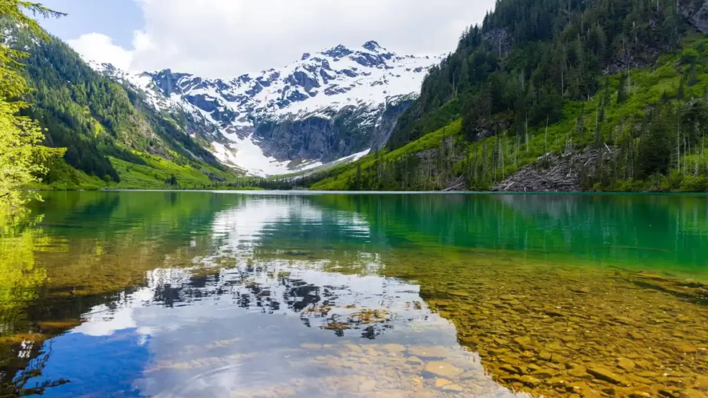
What you do get is a lake sitting in an amphitheater of snow-streaked peaks, with Cadet Peak at 7,186 feet dominating the view and rising roughly four thousand feet above the water. The color shifts through the day — on a calm morning it turns into a near-perfect mirror of the surrounding mountains, which is worth timing your arrival for if you can start early.
There’s also real history here that most competitor pages mention only in passing. Goat Lake was once the site of a mining town, and the current camping area sits near the lake outlet at the location of the old mining town’s hotel. If you’re into Pacific Northwest mining history, this pairs naturally with a side trip to the Monte Cristo ghost town area, accessible from the Barlow Pass side of the Mountain Loop Highway — a different trailhead, but part of the same historical mining district.
One important disambiguation: Washington has more than one trail called “Goat Lake.” There’s also a Goat Lake near the Olympic Peninsula (off the Dungeness River) and a separate Goat Lake loop through the Goat Rocks Wilderness near Mount Rainier. If your GPS points you toward a steep scramble along a river valley with class 2/3 sections, you’re on the wrong Goat Lake — this guide covers the Mountain Loop Highway / Elliot Creek trail out of Darrington, which is the mellow, family-friendly one.
Camping at Goat Lake
If you want to turn this into an overnight, the logistics are simple. There are fifteen designated campsites near the lake, no permit required — just self-register at the trailhead — and you need to camp at least 200 feet from the shoreline, with no campfires allowed anywhere at the lake.
Facilities are basic: a vault toilet at the trailhead itself, and two box-style open-air toilets at the campsites. They get heavy use in peak season, so pack out your own toilet paper regardless — a small courtesy that keeps the area usable for everyone after you.
Quick takeaway: No permit paperwork, but real rules — 200 feet from water, no fires, self-register, pack out what you pack in.
Best Time to Go (and How to Beat the Crowds)
The trail is accessible from late spring to early fall, with the best conditions typically found from June through October. Because the grade is gentle and low-elevation compared to many North Cascades hikes, it’s often one of the first “real” lake hikes to melt out each year — which is exactly why it draws a crowd the moment the snow clears.
That popularity is the trail’s one real downside. Trailhead parking fills fast on summer weekends; on one July Saturday, every space in the lot and along the road was taken, with cars idling and waiting. If a quiet trail matters to you, go on a weekday, or arrive at the lot by mid-morning at the absolute latest on weekends — earlier if it’s a holiday.
Is Goat Lake Hike Right for You?
Honestly, this is one of the more forgiving “big” hikes in the state, and the flat grade is the whole reason. It suits:
- Families with older kids who can handle mileage but not steep climbs
- New backpackers wanting an easy first overnight with a real destination
- Hikers recovering from injury who need distance without elevation stress
- Anyone chasing an early-season lake trip before higher alpine trails melt out
It’s less ideal if you’re short on time — the flat-but-long profile means there’s no shortcut to save an hour, and if you want a strenuous leg workout in a small window, look elsewhere on the Mountain Loop Highway.
You might also find our Washington State hiking guides helpful when planning the rest of your trip.
FAQ Section
Is the Goat Lake hike hard?
It’s rated moderate, but that’s almost entirely about distance rather than steepness. At roughly 10.4 miles round trip with about 1,400 feet of gain, the grade stays gentle nearly the whole way, with one short steeper stretch just before the lake.
How long does the Goat Lake hike take?
Most hikers budget five to six hours round trip, depending on fitness and photo stops. Taking the Upper Elliot Trail one way and Lower Elliot the other adds interest without adding real distance.
Are there actually goats at Goat Lake?
No. Despite the name, wildlife sightings of mountain goats here are essentially nonexistent. The name reflects the surrounding terrain, not resident animals.
Do you need a permit for the Goat Lake trailhead?
You need a parking pass — a Northwest Forest Pass, America the Beautiful Pass, or a day-use fee paid via Recreation.gov’s Scan & Pay. Camping at the lake itself requires no permit, just self-registration at the trailhead.
Can you camp at Goat Lake?
Yes. There are about fifteen designated sites near the lake. Camp at least 200 feet from the shoreline, and note that campfires are not allowed anywhere in the camping area.
Is the Goat Lake trail dog-friendly?
Yes, dogs are welcome on leash. Given the popularity of the trail and shared campsites near the water, keeping dogs leashed is both required and considerate.
How do I get to the Goat Lake trailhead?
From Granite Falls, drive the Mountain Loop Highway east about 31 miles to the end of pavement, continue 3.5 miles, and turn onto the road signed “Elliot and Goat Lakes” (Forest Road 4080). From Darrington, it’s about 22 miles south on the Mountain Loop Highway to the same turnoff.
Is this the same Goat Lake as the one near Mount Rainier or the Olympic Peninsula?
No — Washington has multiple trails named Goat Lake. This guide covers the Mountain Loop Highway / Elliot Creek trail near Darrington, which is longer but far gentler than the steeper Goat Lake routes in the Olympics or Goat Rocks Wilderness.