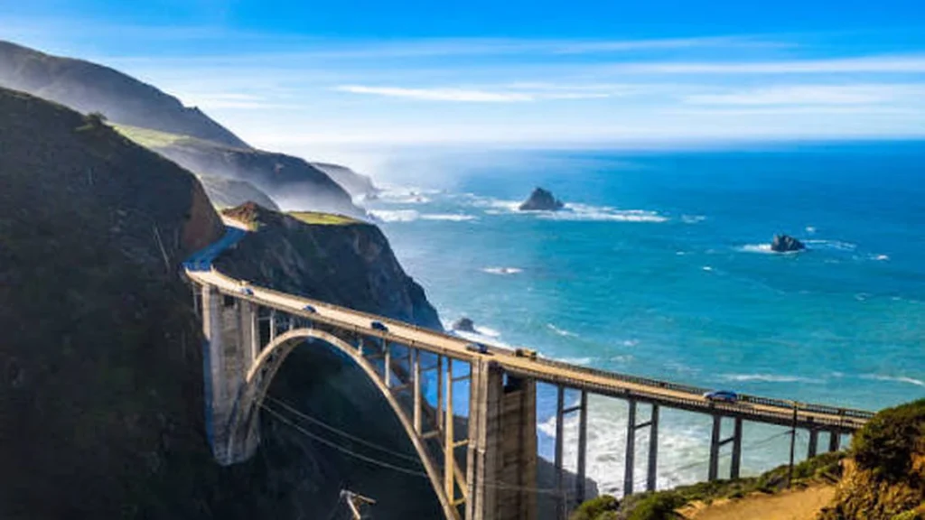
The first time you round the curve past Garrapata and the whole coastline drops away beneath you, you understand why photographers keep coming back to Big Sur. It’s not one photo spot — it’s forty miles of them, strung along a two-lane road with almost nowhere to safely pull over.
Quick answer: The best Big Sur photo spots are Bixby Creek Bridge, Pfeiffer Beach’s Keyhole Arch, McWay Falls, and Garrapata State Park’s Calla Lily Valley. Shoot Bixby at golden hour from the Old Coast Road overlook (new parking rules restrict the bridge itself), Pfeiffer Beach at low tide near sunset, and McWay Falls from the roadside vista point.
That one paragraph would have been enough five years ago. It isn’t anymore, because the rules at the most photographed spot in Big Sur just changed.
The Icon: Bixby Creek Bridge (and the New Parking Rules)
Bixby Creek Bridge has been the postcard shot of Highway 1 since it was completed in 1932, and it’s still one of the tallest single-span concrete bridges in the world. That’s exactly the problem. So many cars stop for the photo that Monterey County has started actively discouraging it.
As of late July 2026, a parking moratorium is in effect around the bridge: no stopping or parking within roughly 900 feet north and 700 feet south of it. The turnouts that used to hold the classic postcard shot are now closed off, largely because of the traffic backups and safety hazards visitors were creating.
Here’s what that means for your photo. You have three legal options now:
- Old Coast Road overlook — walk a short distance up this dirt road opposite the bridge’s north end for a full side profile of the span with the canyon and ocean behind it.
- Castle Rock Viewpoint — a short walk north of the bridge, giving you the bridge plus the offshore rock formation in one frame.
- Hurricane Point — about a mile south, up the hill, with a wide pullout and a more distant, dramatic view of the bridge tucked into its canyon.
None of these require you to stop in a restricted zone, and honestly, they’re better compositions than the roadside shot everyone already has.
Quick takeaway: The classic roadside Bixby shot is no longer a safe or legal option in most spots. Shoot from Old Coast Road, Castle Rock, or Hurricane Point instead — and never stop in a travel lane for a photo, no matter how good the light looks.
Pfeiffer Beach & the Keyhole Arch Light Show
Pfeiffer Beach is the one with the purple sand, and it’s every bit as strange and beautiful as it looks in other people’s photos. The manganese garnet that colors the sand is most vivid right after a winter storm, so don’t skip a visit just because the sky is gray.
Access is via the narrow, 2-mile Sycamore Canyon Road off Highway 1 — no RVs, no trailers, and slow going in the dark. Expect a per-vehicle fee in the $12–$15 range, generally cash-preferred, and a parking lot with roughly 100 spots that fills before 10 a.m. on weekends.
The real draw for photographers is Keyhole Arch, the sea stack with a hole punched through it by the surf. For about 30 minutes leading up to sunset in late December through mid-January, the sun lines up directly with the opening and shoots straight through it — locals call it the light show. Marine layer or cloud cover can kill it even in peak season, so treat it as a bonus, not a guarantee.
Practical notes:
- No reservation is required, but arrive at least an hour before sunset for parking.
- Low tide exposes far more of the purple sand and the tide pools around it.
- Weekday visits in fall or spring get you the same light with a fraction of the crowd.
McWay Falls: Is It Still Accessible?
McWay Falls is the shot everyone screenshots before they even book their trip — an 80-foot waterfall that drops straight onto a beach and into a turquoise cove in Julia Pfeiffer Burns State Park, with no rainbow mist, just a clean fall onto sand you’re not allowed to walk on.
Here’s the update most articles don’t have: the McWay Falls Overlook Trail has been closed at times due to slope erosion. When it’s closed, you can still get a strong photo directly from the Highway 1 turnout above, though the angle is a bit more distant than the trail viewpoint. Check current Los Padres National Forest and Caltrans road condition pages before you go, since closures shift with the weather.
Spring brings wildflowers around the falls and the best odds of that saturated turquoise water. Sunrise and sunset both work here, since the cove faces almost due west but the cliffs create shade pockets worth watching for.
Garrapata State Park’s Hidden Angles
Garrapata gets a fraction of the crowd Bixby and Pfeiffer pull, which is exactly why it’s worth your time. It’s really several photo spots in one park:
- Calla Lily Valley — a small stream flanked by wild calla lilies, blooming mid-February through April, backed by ocean bluffs.
- Soberanes Point — short bluff-top trails with panoramic coastline views and some of the best wildflower color in spring.
- Garrapata Beach — a long sandy stretch with sea stacks, popular with elopement and proposal photographers for its uncluttered backdrops.
Because Garrapata has multiple pullouts along Highway 1 rather than one central lot, it’s much easier to find parking here than at Pfeiffer or Bixby, even on a busy Saturday.
Underrated Spots Most Guides Skip
Most Big Sur roundups repeat the same five or six locations. A few that deserve more attention:
- Point Sur State Historic Park — the lighthouse sits on a dramatic sea stack that looks like an island from the highway turnout.
- Point Lobos State Natural Reserve — technically just north in Carmel, China Cove’s emerald water and Bird Island Trail are excellent for wildlife and seascape shots, and April–May brings seal pups.
- Big Creek Bridge — a smaller double-arch span that gets a fraction of Bixby’s attention, with lookout points at both ends and no current parking restrictions.
- Old Coast Road — beyond its Bixby overlook, this dirt route (4WD or mountain bike when dry) reconnects with Highway 1 near Andrew Molera State Park and offers coastal views with almost no other visitors.
Best Time of Day, Season & Tide to Big Sur Photo Spots
Big Sur photography is as much about timing as location.
| Factor | What to Know |
|---|---|
| Golden hour | Best light on Bixby Bridge and most west-facing coves; arrive 45–60 min before sunset |
| Marine layer / fog | Common mornings, especially summer; can ruin sunrise shots but adds mood to forest scenes |
| Tide | Low tide is essential for Pfeiffer Beach’s purple sand and tide pools; check tide tables the day before |
| Wildflowers | Calla lilies mid-Feb–April; general coastal wildflowers peak in spring |
| Whale migration | Southbound Dec–Feb, northbound (best viewing, mothers closer to shore) March–May; Point Lobos and Garrapata headlands are the most reliable spots |
| Big Sur International Marathon | Late April; the highway closes to cars for a few hours, an unusual chance to shoot the road itself without traffic |
Quick takeaway: If you can only control one variable, control timing. The exact same spot photographed at midday traffic and at golden hour with a falling tide can look like two different places.
A One-Day Big Sur Photography Itinerary
If you’re driving down from Monterey or Carmel-by-the-Sea for a single day, this order minimizes backtracking and puts you at the best light for each stop:
- Morning — Point Lobos or Garrapata State Park (soft light, fewer crowds)
- Midday — Bixby Bridge overlooks (Old Coast Road / Castle Rock / Hurricane Point), then continue south
- Early afternoon — McWay Falls overlook, Julia Pfeiffer Burns State Park
- Late afternoon — Head back north toward Pfeiffer Beach
- Golden hour / sunset — Pfeiffer Beach and Keyhole Arch, timed to low tide if possible
Fill your tank in Monterey or Morro Bay before you start — gas stations are scarce along the drive itself.
Gear, Safety & Etiquette
- A wide-angle lens covers most of Big Sur’s coastal compositions; a longer lens is worth packing separately for whale watching.
- A tripod and a graduated ND filter help balance a bright sky against darker cliffs at sunset.
- Drones are generally restricted in California State Parks and on most Big Sur beaches — check current rules before flying, since violations carry real fines.
- Never park in a travel lane, on the bridge itself, or in a posted no-parking zone to get a shot — it’s the exact behavior that led to the 2026 Bixby restrictions in the first place.
Big Sur rewards patience more than any single lens or app. The light changes fast, the fog rolls in and out on its own schedule, and the best photo of the day is often the one you didn’t plan for.
You might also find our California travel guides helpful when planning the rest of your trip.
FAQ Section Big Sur Photo Spots
What is the best photo spot in Big Sur?
Most photographers rank Bixby Creek Bridge and Pfeiffer Beach’s Keyhole Arch as the top two, followed closely by McWay Falls. Each rewards a different time of day, so plan your route around light rather than picking just one.
Where do you park to photograph Bixby Bridge now?
As of a 2026 parking moratorium, stopping is restricted roughly 900 feet north and 700 feet south of the bridge. Use the Old Coast Road overlook, Castle Rock Viewpoint, or the Hurricane Point pullout about a mile south instead.
Is McWay Falls still accessible?
The overlook trail has faced closures from slope erosion. When closed, you can still photograph the falls from the Highway 1 turnout above, just at a slightly greater distance. Check current park and Caltrans notices before visiting.
How much does it cost to enter Pfeiffer Beach?
Expect a per-vehicle fee around $12–$15, generally cash-preferred at an often-unmanned kiosk. No reservation is required, but parking is limited and fills quickly on weekends.
When does the sun shine through Keyhole Arch?
The alignment typically happens for about 30 minutes right before sunset, from late December through mid-January. Cloud cover or marine layer can block it even during that window, so treat it as a bonus rather than a guarantee.
What’s the best time of year for Big Sur photography?
Spring brings wildflowers and whale calves close to shore; winter offers the Keyhole Arch light show and dramatic storm light; summer has the most crowds and the most morning fog. Fall is the quietest shoulder season.
Are drones allowed in Big Sur?
Drone use is generally restricted in California State Parks and on most beaches in the area. Check current rules for each specific park before flying, since restrictions and fines can apply.
Is there a single-day itinerary that covers the main spots?
Yes — starting north at Point Lobos or Garrapata in the morning, then Bixby Bridge midday, McWay Falls early afternoon, and finishing at Pfeiffer Beach for sunset covers the core route without much backtracking.