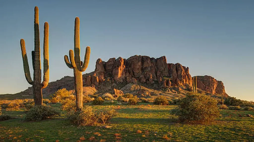
The Superstition Mountains rise so abruptly out of the desert east of Phoenix that they look staged — like someone dropped a jagged wall of red rock into flat scrubland just to see what would happen. What happens is over 100 miles of trail, a gold mine legend that’s swallowed more search parties than treasure hunters, and some of the best sunrise hikes in the Southwest.
Quick answer: Superstition Mountain trails range from the flat, half-mile Native Plant Trail to the grueling 5.5-mile Superstition Ridgeline traverse. Most hikers start at Lost Dutchman State Park (Siphon Draw, Treasure Loop) or the Peralta Trailhead (Peralta Trail to Fremont Saddle, Weaver’s Needle views). Entry runs $7–$10, and October through April is by far the safest and most scenic window.
What Makes the Superstition Mountains Worth the Drive
Most Phoenix-area mountains are gentle. The Superstitions aren’t. The range sits in Pinal County near Apache Junction, bordering Lost Dutchman State Park, a 320-acre park at roughly 2,000 feet elevation that acts as the main gateway into the wilderness beyond.
The name carries weight for a reason. Generations of prospectors have chased the story of a hidden gold mine somewhere in these peaks, and the legend is baked into everything nearby — the state park’s name, a museum dedicated to preserving the mountains’ history and legends, even the ghost town down the road. You don’t need to believe in buried gold to feel why people keep looking. The terrain genuinely swallows landmarks; a saddle that looks obvious from below disappears once you’re inside a canyon.
Trails here also lead into Tonto National Forest and the Superstition Wilderness Area, so the state park is really just the front door — a lot of the best hiking happens on forest and wilderness land past the park boundary.
Quick Takeaway: This isn’t a stroller-friendly city park dressed up as a mountain. Respect it like backcountry, even on the short trails.
Best Superstition Mountain Trails by Difficulty
With over 100 trails crossing the range, picking one can be paralyzing. Here’s how they actually break down.
Easy trails
Native Plant Trail — A short, mostly flat interpretive loop near the Lost Dutchman visitor center. Good for a warm-up or a hike with young kids, though don’t expect much shade.
Hieroglyphic Trail — A family- and dog-friendly hike where petroglyphs carved by earlier desert inhabitants start showing up roughly a mile and a half in, and a good monsoon can leave seasonal pools along the way. Sunrise or sunset light works best for photographing the rock art.
Moderate trails
Treasure Loop Trail — A 2.4-mile round trip loop with about 500 feet of elevation change, ending near either of the park’s picnic areas. It’s the trail most first-timers do, and for good reason — full mountain views without a brutal climb.
Wave Cave Trail — A 4.7-mile round trip from the Peralta Trailhead that costs a $15 Arizona State Trust Land permit, leading to a rock formation curved like a breaking wave. It’s become an Instagram staple, which means the small parking area fills fast — go at sunrise or expect to circle for a spot.
Peralta Trail to Fremont Saddle — The most photographed trail in the range, and arguably the best value for effort. It’s a straightforward route that typically takes about 75 minutes to reach the saddle, delivering a dead-on view of Weaver’s Needle. Backpacking is an option if you want to push further in.
Hard / expert trails
Siphon Draw to the Flatiron — A roughly 4-mile round trip from the base, though reaching the actual Flatiron summit stretches it closer to 5.8 miles, and it demands real scrambling, including a section climbers call the “10-foot Wall” that guards the final approach. Plan on at least five hours round trip, and go with someone who’s comfortable on exposed rock.
Superstition Ridgeline — A point-to-point traverse starting at Lost Dutchman State Park and ending at Carney Springs Trailhead, generally considered the toughest hike in the range with over 3,100 feet of gain across roughly four miles up. You’ll need a second car or a shuttle, since it doesn’t loop back. Cairns mark the route through the canyon, but the trail turns overgrown past the seasonal creek — long pants save your shins here.
| Trail | Distance (RT) | Elevation Gain | Difficulty | Trailhead |
|---|---|---|---|---|
| Native Plant Trail | ~0.5 mi | Minimal | Easy | Lost Dutchman SP |
| Hieroglyphic Trail | ~3 mi | Moderate | Easy–Moderate | First Water area |
| Treasure Loop Trail | 2.4 mi | ~500 ft | Moderate | Lost Dutchman SP |
| Wave Cave Trail | 4.7 mi | Moderate–steep | Moderate | Peralta Trailhead |
| Peralta Trail / Fremont Saddle | 6 mi (to saddle) | ~1,500 ft | Moderate | Peralta Trailhead |
| Siphon Draw to Flatiron | 5.8 mi | ~2,700 ft | Hard | Lost Dutchman SP |
| Superstition Ridgeline | ~5.5 mi one-way | 3,100+ ft | Expert | Lost Dutchman SP → Carney Springs |
Quick Takeaway: If you only have time for one hike, Peralta to Fremont Saddle gives you the classic Weaver’s Needle view for the least effort. If you want to earn it, the Flatiron delivers the best bragging rights within a single day.
Trailheads, Access Points & Fees
Where you start matters as much as which trail you pick, because fees, parking, and crowd levels vary a lot by trailhead.
Lost Dutchman State Park — Entry runs $10 per vehicle for one person or $20 for two to four people, plus $5 for individuals or bicycles, though some listings show a lower $7 vehicle rate, so check current pricing before you go. Only cash or a swipeable Visa/Mastercard is accepted — no chip readers, tap payment, or mobile wallets, which catches a surprising number of visitors off guard. Hours run roughly 6 a.m. to 3:30 p.m. most days, though other sources list evening closing times as late as 7 or 8 p.m., so don’t assume you can start a late-afternoon hike without confirming the day’s posted hours. Walk-in entry and hiker drop-off aren’t permitted for safety reasons — you need to actually drive in and park.
Peralta Trailhead — Reached via Forest Road 77, this trailhead sits on a mix of Tonto National Forest and Arizona State Trust Land. Trails accessed from here, like Wave Cave, require a separate $15 Arizona State Trust Land permit rather than the state park fee — easy to miss if you assume one payment covers everything in the range.
First Water Trailhead — The jumping-off point for Hieroglyphic Trail and several backcountry routes into the wilderness area; generally no fee beyond a Tonto National Forest parking pass where required.
Quick Takeaway: Three different trailheads can mean three different permit systems. Confirm which land manager covers your specific trail before you drive out — Google Maps won’t tell you.
Best Time of Year and Day to Hike
Fall, winter, and spring are the recommended visiting months, since summer gets very warm — and “very warm” undersells it. Afternoon temperatures on exposed rock regularly climb well past 100°F from June through September.
Spring brings the payoff for waiting: after a wet winter, the desert blooms with poppies, desert zinnias, and golden asters, and even the cacti flower and fruit. If you’re hiking any other season, sunset is the next best option, since the mountain’s rock faces glow against the setting sun.
Start early regardless of season. One pair of hikers in their mid-60s arrived at 6:45 a.m. for the Flatiron route specifically to beat both the heat and the crowds, and popular photo-op trails like Wave Cave fill their small lots by mid-morning on weekends.
Quick Takeaway: Treat any trail longer than 2 miles as a sunrise hike between May and September. There’s no shade to hide behind once the sun is up.
Safety: What Actually Goes Wrong Out Here
This is the part most trail guides gloss over, and it’s the part that matters most.
The Flatiron route has a real fatality history. In 2022, a 21-year-old hiker fell 700 feet while taking a photo near the Flatiron summit, and in 2024 an experienced hiker died in a separate fall on the same route. Both incidents happened on exposed, unmarked terrain near the top — exactly where hikers relax because they think the hard part is over.
Beyond falls, the two biggest risks are heat and monsoon flooding. Desert heat kills through dehydration and heat stroke, often on hikers who underestimate how quickly conditions turn on an unshaded ridge. Every person should carry at least one gallon of drinking water per day, and summer temperatures often exceed 100°F. Monsoon season (July through September) also brings sudden, hard rain that turns dry washes into fast-moving water with little warning — the same canyons that look scenic and dry most of the year.
Getting lost is more common than either. Cell service is limited across much of the range, so downloading offline maps before you go is essential, and letting someone know your plans matters especially on remote trails. Even well-traveled routes rely on cairns for guidance, and those markers can vanish once trails become overgrown past seasonal creek crossings.
Quick Takeaway: More hikers get in trouble from heat, dehydration, and route-finding than from any single dramatic fall — but the falls happen on the exact trails marketed as “moderate,” so don’t let a trail’s popularity fool you into skipping preparation.
Wildlife You’ll Actually Encounter
Bobcats, javelina, mountain lions — especially on remote trails and around caves — coyotes, and owls all live in the range, alongside desert mule deer and jackrabbit. Most of these animals are nocturnal or crepuscular, so you’re most likely to spot them early morning or at dusk rather than midday.
Rattlesnakes are common in warmer months and tend to sun themselves on open trail sections in spring and fall mornings — watch where you step and where you place your hands if you’re scrambling.
The park has also become a strong birdwatching destination, particularly in winter when migratory species move through.
What to Pack
- One gallon of water per person, minimum, for anything beyond a short loop
- Offline trail map (downloaded before you lose signal)
- Sun protection: wide-brim hat, sunscreen, sunglasses
- Sturdy boots with ankle support for scrambling sections
- Long pants for overgrown or brushy stretches
- Cash or a swipeable card for park entry
- A headlamp if there’s any chance you’re finishing near dusk
Beyond the Trailhead
If you’ve got energy left, Goldfield Ghost Town and the Superstition Mountain Lost Dutchman Museum sit close by and round out the legend you’ve just been hiking through. Lost Dutchman State Park also offers camping if you want to base out of the area for a multi-day trip rather than driving back to Phoenix each night.
Final Thoughts
The Superstition Mountains reward preparation more than fitness. A beginner who starts early, carries enough water, and picks Treasure Loop or Peralta to Fremont Saddle will have a better day than an experienced hiker who underestimates the Flatiron in July. Pick the trail that matches your actual conditioning, not your ego, and you’ll understand why people keep coming back to these mountains — gold mine or not.
Ready to plan your trip? Pick your trailhead, check that day’s park hours, and download an offline map before you leave cell service behind.
For more inspiration like this, take a look at our Southwest USA travel guides.
FAQ Section
Is the Flatiron hike dangerous?
Yes, relative to most day hikes near Phoenix. It requires scrambling on exposed rock, and there have been fatal falls near the summit in recent years. Go with experience, good footwear, and turn back if conditions look unstable.
How long does it take to hike Siphon Draw to the Flatiron?
Plan on at least five hours round trip for the roughly 5.8-mile route, longer if you’re not used to scrambling or the heat slows your pace.
What is the legend of the Lost Dutchman gold mine?
It centers on a hidden gold mine supposedly located somewhere in the Superstition Mountains, tied to 19th-century prospector Jacob Waltz. No mine has ever been verified, but the legend shaped the region’s name, museum, and tourism identity.
Are dogs allowed on Superstition Mountain trails?
Many trails, including Wave Cave and Hieroglyphic Trail, are dog-friendly. Always keep dogs leashed, bring extra water for them, and avoid hiking with pets during summer heat.
Do I need a permit to hike the Superstitions?
It depends on the trailhead. Lost Dutchman State Park charges a standard vehicle entrance fee, while some Peralta Trailhead routes require a separate Arizona State Trust Land permit.
What is the easiest trail in the Superstition Mountains?
The Native Plant Trail at Lost Dutchman State Park is the flattest, shortest option, followed closely by Hieroglyphic Trail for those wanting a bit more distance with petroglyphs as a payoff.
When is the best time to see wildflowers there?
Spring, following a wet winter, typically produces the best wildflower blooms, including poppies and golden asters across the desert floor.
Can I camp near the trails?
Yes — Lost Dutchman State Park offers a campground, making it a convenient base for hiking multiple trails over several days.