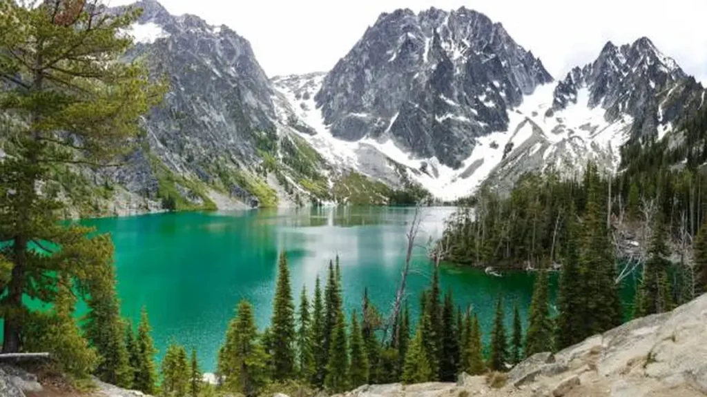
There’s a moment on the Colchuck Lake trail, right after you clear the last stand of trees, when the lake just appears — glacier-blue, ringed by granite, with two jagged peaks standing guard on the far shore. Most people stop walking for a second. It’s that kind of view.
Colchuck Lake sits in Washington’s Alpine Lakes Wilderness near Leavenworth and serves as the main gateway into the Enchantments. The round trip runs roughly 8 to 9 miles with about 2,200 to 2,300 feet of elevation gain, and most hikers finish in five to six hours. You’ll need a free self-issued day permit at the trailhead, and a Northwest Forest Pass to park.
Trail Overview & Stats
Here’s the quick version before we get into the details:
| Stat | Detail |
|---|---|
| Round-trip distance | 7.6–9.1 miles (sources vary slightly depending on how far you explore the shoreline) |
| Elevation gain | ~2,154–2,300 ft |
| Difficulty | Moderate to hard |
| Average time | 5–6 hours round trip |
| Trailhead | Stuart Lake Trailhead, off Icicle Creek Road |
| Dogs | Not allowed |
| Permit | Free self-issued day permit; overnight requires an Enchantments lottery permit |
| Best season | Late June through October |
Different trackers report slightly different mileage because people measure to different points along the shoreline — some stop at the first view, others walk the extra stretch toward the south end. Either way, budget for a full day.
Step-by-Step Route Breakdown
The hike starts at the Stuart Lake Trailhead and immediately drops you into thick forest, with Mountaineer Creek running alongside the trail. This first stretch — roughly a mile and a half — is shaded, gentle, and a good warm-up.
After you cross a log bridge over the creek, the climbing starts in earnest. The trail steepens through a series of switchbacks. Around the two-mile mark, you’ll hit a signed junction: stay left for Colchuck Lake, straight continues to Stuart Lake. This is the spot people miss most often, so keep an eye out for the sign.
Past the junction, the trail gets rockier and steeper. You’ll cross another narrow bridge over Mountaineer Creek, then work through a stretch of boulder-hopping across a talus slope. The creek turns glassy and calm for a short section here — a nice spot to catch your breath before the final push.
The last mile is the toughest: more switchbacks, a rocky scramble over a boulder field, and then the forest opens up. That’s your cue — the lake is close. When you finally reach the shoreline, Dragontail Peak dominates the view straight ahead, with Aasgard Pass visible to its left and the remnants of the Colchuck Glacier off to the right.
If you have energy left, the trail continues along the shore for another two-thirds of a mile toward the base of the glacier’s terminal moraine — just watch for an easy-to-miss junction near a large tarn where the correct path bends left over rock rather than following the more obvious dirt track to the right.
Permits & Passes You’ll Need
Day hikers need a free, self-issued wilderness permit, available at a kiosk right at the trailhead. Fill it out, keep your copy with you, and drop the stub in the box. It’s mostly there to help rangers track usage and assist search-and-rescue if needed.
For parking, you’ll need a Northwest Forest Pass — $5 for a day pass (available at the trailhead kiosk) or $30 for an annual pass. An America the Beautiful federal pass also works.
Overnight camping at Colchuck Lake is a different story. Between May 15 and October 31, camping anywhere in the Enchantments zone — including Colchuck’s shoreline — requires a permit issued through Recreation.gov’s annual lottery. Demand is intense: in a recent lottery year, roughly 39,000 people applied and only about 2,444 permits were issued, a success rate near 6%. If you don’t win the lottery, a small number of walk-up permits are available at the ranger station each morning, but competition is fierce in peak season.
Parking and Getting to the Trailhead
From Leavenworth, head out Icicle Creek Road (off Highway 2 on the western edge of town), then continue onto Forest Service Road 7601 to reach the Stuart Lake Trailhead. Budget more time than Google Maps suggests — the last few miles of FR 7601 are rough and pothole-riddled, and most vehicles need to creep along.
The lot holds around 30 cars, with a portion reserved for overnight permit holders — don’t park there if you’re day-hiking. This is one of the most heavily ticketed trailheads in the state, so don’t skip displaying your pass. On busy weekends, the lot can fill before sunrise; some hikers arrive as early as 3 or 4 a.m. If the lot is full, overflow parking is allowed along the right side of FR 7601, which adds roughly a mile each way to your hike.
There’s no cell coverage for the final few miles of the drive in, so download offline directions before you leave town.
Best Time to Hike Colchuck Lake
The trailhead access road typically closes from November through May, which narrows the realistic hiking window to late June through October. Snow often lingers into mid-July, so if you want a snow-free trail, aim for late July onward.
Late September through mid-October is the sweet spot for many hikers — cooler temperatures, fewer bugs, and the western larches around the lake turn a brilliant gold. Mosquitoes can be relentless from June through August, especially near the creek crossings, so pack repellent if you’re going in summer.
How Hard Is the Colchuck Lake Trail, Really
The stats — under 9 miles, around 2,300 feet of gain — sound approachable, and for reasonably fit hikers, they are. But several things make this trail feel harder than the numbers suggest. The first mile and a half is nearly flat, which means almost all the elevation gets packed into the remaining three miles. A lot of that climbing happens over rock steps, boulders, and uneven talus rather than smooth dirt, which is tougher on knees and ankles than a comparable gain on a groomed trail.
Trekking poles help a lot here, both on the climb and especially on the descent. If you’ve done other moderate-to-strenuous Washington hikes and have some cardio base, you’ll manage fine — just don’t treat the mileage alone as the full picture.
Beyond Colchuck Lake — Aasgard Pass & the Enchantments
Colchuck Lake is the first major waypoint on the full Enchantments traverse, an 18-mile-plus thru-hike that continues up and over Aasgard Pass (also called Colchuck Pass) into the Core Enchantments before descending past Snow Lakes to a second trailhead. Aasgard Pass itself is brutal — close to 2,000 feet of gain packed into less than a mile of loose scree and rock, usually done as part of a much longer day.
Some hikers do the entire traverse in a single very long day; most spread it over two or three with an overnight permit. If you’re just planning the Colchuck Lake out-and-back, you won’t need anything beyond the day-use permit — Aasgard Pass and beyond require significantly more preparation and, for overnight stays, that lottery permit.
READ MORE: Places to Stay in Joshua Tree: Where to Sleep Near the Park
Practical Tips Before You Go
- Dogs are not allowed anywhere in the Enchantments permit area, Colchuck Lake included.
- Toilets are available at the trailhead and near the lake, though conditions can be rough in peak season — bring your own toilet paper and consider a portable waste bag as backup.
- Swimming is doable and popular in the warmer months, though the water stays cold well into summer.
- Wildlife sightings, including mountain goats and deer, are common along the upper trail — give animals space and store food properly.
- Colchuck Lake sits within land that is part of the traditional homeland of the Wenatchi people; being mindful of that history is part of hiking here responsibly.
- If you want a similar payoff with less competition for parking and no permit lottery pressure, nearby Lake Stuart is a gentler alternative worth considering.
Looking for more travel inspiration? Head over to our homepage for more guides like this.
FAQ Section
How long is the Colchuck Lake hike?
Round trip is roughly 7.6 to 9.1 miles depending on how far along the shoreline you go, with most hikers finishing in 5 to 6 hours including breaks.
Do you need a permit for Colchuck Lake?
Yes — a free self-issued day permit at the trailhead for day hikes, plus a Northwest Forest Pass to park. Overnight camping requires a separate Enchantments lottery permit valid May 15 through October 31.
Are dogs allowed at Colchuck Lake?
No. Dogs are prohibited on all trails within the Enchantments permit area, including the Colchuck Lake Trail.
What is the best month to hike Colchuck Lake?
Late July through mid-October is ideal. Snow often lingers into July, and late September to mid-October brings golden larch trees and thinner crowds.
How hard is the Colchuck Lake trail?
It’s rated moderate to hard. The distance and elevation gain are manageable for fit hikers, but a steep, rocky final stretch makes it tougher than the raw numbers suggest.
Can you swim in Colchuck Lake?
Yes, swimming is popular in summer, though the water stays cold even in August.
Where do you park for the Colchuck Lake hike?
At the Stuart Lake Trailhead off Forest Service Road 7601, reached via Icicle Creek Road from Leavenworth. The lot is small and fills early on weekends.
Is Colchuck Lake part of the Enchantments?
Yes — it’s the primary entry point into the Enchantments zone and the first major waypoint on the full Enchantments traverse over Aasgard Pass.